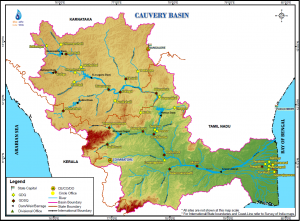
Rivers are major source of irrigation in tamilnadu. Let see some of major rivers that irrigates Tamilnadu. Maximum rivers in Tamil nadu are east flowing rivers and merges at Bay of Bengal.
The state receives 48% rain through the North East monsoon and 32% through the South West monsoon.
Some major rivers of the state are as under:
BHAVANI
Originates : In Palghat Ranges, Kerala
Flows Through: Erode District Of Tamil Nadu
Ultimately Joins: River Kaveri On The Salem Borders
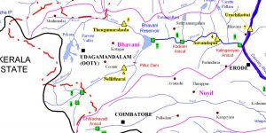
Bhavani rises in the silent valley in Palghat ranges in the neighbouring state of Kerala, after receiving Siruvani, it flows into CoimbatoreDistrict where it gets reinforced by the Kundah River before entering Erode District in Gopichettipalaiyam.
Bhavani is more or less a perennial river fed mostly by the South West monsoon. North East monsoon also supplements its water resources. This river runs for over hundred miles through Erode traversing through Bhavani and Gopichettipalaiyam Taluks (also spelt as Taluka). It feeds the Bhavanisagar reservoir, which takes an easterly course flowing through Gopichettipalaiyam, Satyamangalam and Bhavani Taluks, before it ultimately joins river Kaveri on the Salem borders.
Kaveri
Source : Talakaveri In Karnataka
Length: 760-kms
Coverage: Karnataka And Tamil Nadu
Main Tributaries: Bhavani, Noyil, Amaravati And Kollitam
Kaveri (also spelt as Cauvery) is among the most sacred rivers of India and is known as “the Dakshina Ganga” or “Ganga of the South”. It flows through a length of 760-kms and its main tributaries are Bhavani, Noyil, Amaravati and Kollitam.
Mythology
Mythology has several versions about Kaveri’s descent to the earth. The most popular is that a king by the name of Kavera, who lived in the Brahmagiri hills, prayed to Lord Brahma for a progeny.
He was blessed with a daughter whom he named Kaveri. She was the water manifestation of the human form. The great sage Agastya, who married her, contained her in his ‘Kamandalu’ (also spelt as Kamandal) (spouted jug). When a drought encompassed the land, Ganesha in the guise of a crow, tipped the Kamandalu and out flowed Kaveri.
Along The River
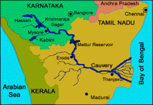
In Coorg district of Karnataka, Kaveri has its origin in Talakaveri at the height of 1,341 meters. The first dam built on this river is ” Krishnaraj Sagar ” at 19-km from Mysore where it meets with Hemawati and Laxmantirth rivers.
After 25-km from Srirangapatnam it meets Kabini and Suvarnawati rivers and near Shivsamundaram, it falls from the height of 90 metres and creates many beautiful waterfalls and springs. At 64 kms from this place, it forms the border of Karnataka and Tamil Nadu. Here, it meets with Simsa and Akrawati rivers.
In Tamil Nadu, it flows in east direction but from Hogenakkel waterfalls, it flows in south direction. At 45-km from Maitoor, it meets with its main assistant river Bhavani. When it enters into Tiruchirapalli District, it meets with Noyil and Amaravati rivers. Here it is the widest of whole of its path and hence, it is called “Akhand Kaveri”.
After Tirucharapalli, it divides into two branches. Upper branch is called ‘Kaileroon’ and falls in Bay of Bengal near Portonova. Southern branch is called ‘Kaveri’, which also falls in Bay of Bengal near Taranqubar.
Noyil
Tributary Of : Kaveri
Noted For: Capricious Nature
Irrigates: Areas In Palladam Taluk Of Coimbatore District And Dharapuram Taluk Of Erode.
Noyil River, a tributary of Kaveri is noted for its capricious nature. This is fed mostly by the Southwest monsoon but the Northeast monsoon brings rains and this very often results in floods. Inspite of its unpredictable character, the river helps to irrigate considerable areas in Palladam Taluk (also spelt as Taluka) of Coimbatore District and Dharapuram Taluk of Erode.
Cheyyar
Tributary Of : River Palar
Flows Through: Chengam Taluk Of Tiruvannamalai District
Cheyyar, Thcnpennai, Ramandala Nagu, Thurinjalaru and Suganadhi are the important seasonal rivers flowing in Tiruvannamalai district. Cheyyar is a tributary of Palar, which originates in Kolar.
River Cheyyar flows through Chengam Taluk (also spelt as Taluka) of Tiruvannamalai district. It receives rain during the Northeast and Southwest monsoon periods. Cheyyar River passes through several villages of Chengam Taluk, and is the major source of irrigation. The Taluk has different types of soil, such as black, red loam and sandy loam. Major crops raised in the Taluk are paddy and groundnut.
Magaral lies on the northern banks of Cheyyar River. Across the river lies the Kadambarkoyil temple.
Palar
Rises In: Eastern Ghats Near Coimbatore
Flows Through: Vellore And Chingelput Districts Of Tamil Nadu
Terminates: In The Bay Of Bengal Near Caturangapattinam
Palar River rises in the Eastern Ghats near Coimbatore, runs through Vellore and Chingelput districts of Tamil Nadu and terminates into the Bay of Bengal near Caturangapattinam.
Palar River used to supply good drinking water to 30 towns on its banks and 50 villages surrounding it. The Palar river water was also used by the villagers to cultivate their land.
The Pollution Effects
Now, there are a number of tanneries on the banks of the River Palar. They let out the effluents in the Palar River. So, now the river water has been polluted and it is not useful for drinking or agricultural purposes. Due to pollution, the people are suffering from a number of diseases like asthma, skin disease and stomach ailment, etc. Thousands of acres of fertile land have become wasteland and it is not used for cultivation.
TNPSC Notes brings Prelims and Mains programs for TNPSC Prelims and TNPSC Mains Exam preparation. Various Programs initiated by TNPSC Notes are as follows:-
- TNPSC Mains Tests and Notes Program
- TNPSC Prelims Exam 2020- Test Series and Notes Program
- TNPSC Prelims and Mains Tests Series and Notes Program
- TNPSC Detailed Complete Prelims Notes


