Thamirabarani River
Originates: In Western Ghats In Tirunelveli District
Tributaries: River Servalar, Pachaiyar And Chittar
The river Tambaraparani (Now people call Tambaraparani as Thamirabarani) originates on the eastern slopes of Western Ghats in Tirunelveli district of Tamil Nadu. The origins of Tambarabarani and its tributaries are situated at the peaks called “Aduppukkal Mottai”, “Agathimalai” and “Cherumunji Mottai”, at an altitude of about +2,000m from the mean sea level.
The Tambarabarani basin is situated between latitudes 8.21′ N and 9.13′ N and between longitudes 77.10′ E. Vanatheertham waterfalls (40 m deep) is located close to the origin of the main river. This river joins the Papanasam Reservoir at its 16th km. The river has 4 tributaries called Peyar, Ullar, Karaiar and Pambar upstream of Papanasam Reservoir.
The River Servalar, a main tributary of Tambarabarani joins the main river at a running distance of 22-km. Another tributary Manimuthar originates in the Agathimalai Ranges at an altitude of about +2,000 m above mean sea level. It joins the Tambarabarani at its 36th km near Ambasamudram. Gadana River joins at its 43rd km on the left.
The Tributaries
The Gadana River has two tributaries namely Jambunadhi and Ramanadhi. There are six anicuts across Gadana and 7 across Ramanadhi. There is a reservoir across Gadana with a storage capacity of 352 m.cft. The Gadana River irrigates 3,887.09 hectares of wetlands. There is a reservoir of 152 m.cft. capacity across Ramanadhi. This river irrigates 2,023.47 hectares of wetlands.
Pachaiyar, the next tributary joins Tambarabarani at its 61st km near Gopalasamudram. This tributary originates from the Kalakkadu reserve forests at an altitude of about 1,300 m above mean sea level. It has 12 anicuts across and irrigates 6,151.35 hectares of wet and dry lands. Chittar, a tributary of Tambarabarani joins it at its 73rd km, running almost parallel to Tambarabarani till its confluence.
The river Tambarabarani, after the confluence of Chittar, travels another 23-km where it has the Srivaikundam anicut. From thereon, it runs eastwards for 30-km and enters the Gulf of Mannar near Palayakayal.
Chittar
Tributary Of: River Tambarabarani
Originates In: Courtallam Hills In Tenkasi And Shencottah Taluks Of Tirunelveli District
Length: 80-km
The Chittar has 5 tributaries, 3 sub tributaries and numerous small streams contributing the flow. The Chittar and its tributaries have their origin in Courtallam hills in Tenkasi and Shencottah Taluks (also spelt as Taluka) of Tirunelveli District. The Chittar runs for about 80 kms before it confluences with Tambaraparani.
The Chittar’s first tributary is Ayindaruviar (River of Five Falls), which has an anicut and irrigates about 293.40 hectares of land. Hariharanadhi confluencing with Chittar has two sub tributaries called, the Gundar and Mottaiar. The Mottaiar has a reservoir and a pick up anicut feeding 141.64 hectares.
The Gundar, which is also called “Karungalar” has 7 anicuts and a reservoir. They irrigate 465.39 hectares of land altogether. Mottaiar joins Gundar and Gundar joins Hariharanadhi. The Hariharanadhi itself has 7 anicuts and irrigates 445.10 hectares of land.
Aludakanniar, another tributary to Chittar has 8 anicuts irrigating 827.47 hectares of land. Hanumanadhi is the next tributary to Chittar. It has a sub tributary called Karuppanadhi. There is a reservoir of 185 m.cft, capacity across Karuppanadhi besides 6 anicuts. These irrigate 3,844.59 hectares, the Hanumanadhi has 14 anicuts and irrigates 4,046.94 hectares and the last tributary to Chittar is Uppodai. Uppodai irrigates 445.16 hectares through two anicuts. The Chittar River itself has 17 anicuts irrigating 8,903.27 hectares of land.
The Servalar
Tributary Of: River Tambarabarani
Diversion Weir: Marks The Confluence Of Servalar And Tambaraparani
The River Servalar, a main tributary of Tambarabarani joins the main river at a running distance of 22-km. The diversion weir marks the confluence of Servalar and Tambaraparani.
A diversion weir was constructed just below the confluence of Servalar. The weir has a storage capacity of 49 M.cft. The Powerhouse, just below functions with a gross head of 91 m and a capacity 4 x 7 MW.
The Servalar Reservoir is across Servalar River. This is also a Masonry Gravity Dam of 450 m long and 53 m high. The reservoir has a storage capacity of 1,225 Mcft. The Power House at the reservoir will have an installed capacity of 20 MW. The Papanasam and Servalar reservoirs are interconnected by, a tunnel of 10,886 feet long.
The tailrace water from Papanasam Power House joins the main river Tambarabarani and it serves the wetlands on both sides enroute before it confluences with Gulf of Mannar. Many tributaries join the river course in the plains both on the right and left flanks.
Ponnaiyar
Flows: Across The Boundary Between Cuddalore And Villupuram Taluks
Joins The Bay Of Bengal: At About 3 Miles North Of Cuddalore
Ponnaiyar River flows across the boundary between Cuddalore and Villupuram Taluks (also called as Taluka) and joins with the Bay of Bengal about 3 miles north of Cuddalore.
The Gadilam River, which starts in eastern part of Tirukkoyilur Taluk of Villupuram district flows through Cuddalore Taluk. In Cuddalore Taluk, Malattar joins it on the right and then it flows into the Bay of Bengal at a point, just north of Cuddalore.
The Ponnaiyar and the Gadilam are connected by a river course called “the Malattar”, which serves to carry the surplus water from Ponnaiyar to Gadilam.
Vaigai River
Rises: In Varushanad Hills Of Western Tamil Nadu
Length: 150 Miles
Chief Tributaries: Siruliar, Theniar, Varaha Nadi, And Mangalar
Rising in the Varushanad Hills of western Tamil Nadu, Vaigai River initially flows northeast through the Kambam and Varushanad valleys. In its central it flows eastward into the Vaigai reservoir at 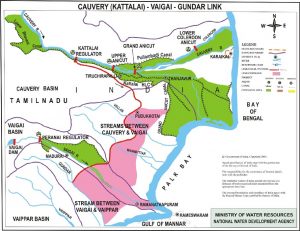 Narasingapuram. Near Sholavandan it bends to the southeast, passing Madurai town on its course to its mouth on Palk Strait, which separates the southeast coast of India from Sri Lanka.
The Vaigai River rarely floods and its chief tributaries are the Siruliar, Theniar, Varaha Nadi, and Mangalar. It flows through a length of 150 miles (240-km), generally southeast.
The Vaigai River basin (indicating agricultural areas) in Tamil Nadu has an area of 7,000-sq-km where current (and projected) supplies of surface and groundwater are not deemed sufficient to meet current (and projected) needs. In 1985 a tunnel diverted waters from the Periyar River in Kerala under a contentious 999-year agreement between Kerala and Tamil Nadu.
The western and northwestern parts of the basin receive heavy rainfall during the monsoons, with an average rainfall of 850mm over the basin. The land use is predominantly agricultural (consuming about 3,800 MCM of water annually), with paddy as the primary crop. There are significant water-sharing conflicts within agriculture itself, with the various agricultural areas competing for scarce water supplies.
TNPSC Notes brings Prelims and Mains programs for TNPSC Prelims and TNPSC Mains Exam preparation. Various Programs initiated by TNPSC Notes are as follows:-
- TNPSC Mains Tests and Notes Program
- TNPSC Prelims Exam 2020- Test Series and Notes Program
- TNPSC Prelims and Mains Tests Series and Notes Program
- TNPSC Detailed Complete Prelims Notes